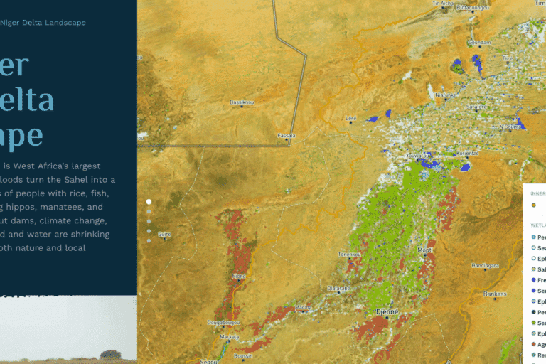
Since 1970, more than a third of the world’s wetlands have been lost, at a rate three times faster than forest loss. To help governments and funders prioritize wetlands in need of protection or restoration, the global nonprofit Wetlands International has launched the new Wetland Atlas. The interactive atlas integrates spatial information on different wetlands with data on their climate mitigation potential, how many people depend on them, and their protection status, the nonprofit said in a press release.
Most of the other maps offer only raw data on the extent of wetlands. Currently, the atlas focuses on the Sahel and the Horn of Africa, regions where wetlands are increasingly vulnerable. “Wetlands account for less than 10% of the area of the Sahel, but they are home of more than 75% of the population and directly support more than 85% of GDP,” Karounga Keita, Sahel director, Wetlands International, told Mongabay.
According to Richard Lee, Wetlands International’s communications director, the tool addresses a major hurdle called “wetland blindness,” where decision-makers undervalue areas like rivers, lakes and peatlands. “Wetlands are invariably seen through a blinkered lens, which views rivers as just pipes for water, lakes as stores to be pumped dry and polluted, and other wetlands as ‘wastelands’ to be converted,” Lee told Mongabay by email. “This view neglects all the other values of healthy wetlands from food security to flood reduction, cultural significance to climate mitigation and adaptation.” To create the new platform, researchers at Wetlands International combined information on biophysical,…This article was originally published on Mongabay