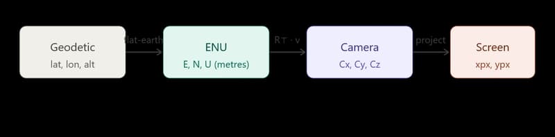
I've been building an Android app that overlays aircraft labels on a live camera feed when you point your phone at the sky. You fetch a plane's position from an ADS-B API, you have your own GPS location, and the goal is to draw a label at the correct pixel on screen. The problem sounds straightforward until you try to implement it. There are four distinct coordinate spaces between the aircraft's G
From GPS Coordinates to Screen Pixels: The Full AR Projection Math
Dhruv Anand·Dev.to··1 min read
D
Continue reading on Dev.to
This article was sourced from Dev.to's RSS feed. Visit the original for the complete story.